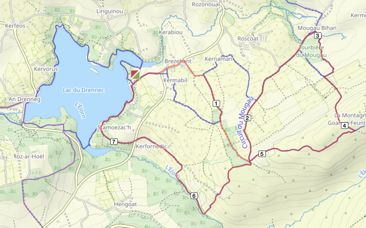
Walk 2 (12.5 or 15km)
12.5km or 15km circular route on tracks, paths and quiet roads.
About this walk
Good shoes are required. This walk has some uphill paths.
It has some great views and takes in the allée couverte.
There are some great picnic spots on route.
The route

Instructions
Turn right out of the gate, then take the first left by our own Croas Penn Ar N’each.
Walk up into Brezehan past the café au route de lin. Keeping left at the triangle.
Note all the roofs with the animals on. The slates are all mined locally and are a speciality of the Monts D’Arrée.
Just after the farm with the green windows and a picture of a turkey turn right up the track behind the farm. You will walk past a big turkey shed.
Keep walking up the track you will start to come into some deep dark woods on the right.
Just before the summit on the right in the woods you will see the Croas Melar. Its worth a little detour to have a look at it properly.
At the summit there are lots of signposts. You are taking the one downhill on the left signposted Allée Couvert. This is a lovely path that winds down the hill turning into a track. Keep following until you get to the road.
At the road turn right.
Follow the road until you get to the Allée Couverte. This is an ancient prehistoric burial site. well worth a look. You can go inside and need to find carved on the walls a dagger and a bare breast.
This is also a good place for a picnic.
When you have rested, continue across the road from the Allée Couverte and enter the walk of the Korrigans. These are small troll like creatures that can be hiding so be careful. You will follow the board walk through marshes and woodlands, across streams and fields. There are some rare plants on this site so watch out for them.

At the end of this path you pass through a stone stile and turn left up towards the crest. This path can be quite steep and wet as it has a steam running over the natural slates in the path. It continues like this until you get above the water table. During your ascent you can look back over Commana and the countryside. You will be also able to see the lake.
Keep following the path once you have reached the top until you come to a junction. To continue on the walk, turn right. You have a great view of the old slate quarries.
Continue following the path between rocky headlands as you start to descend again you will notice on the right there is an outcrop of rocks that has a path going towards them. There is a great view of the lake from up there and it’s a good place for a sit down and to finish the rest of your picnic.
Return to the path and continue to the junction with the signposts. This time turn left and follow the path as it bends to the right. There are great views of the Mont St Michael with the chapel on top, here in the distance or Menez Mikel in Breton.
Keep following this lovely path, you may well notice some beehives up here on the left making most of the abundance of wildflowers.
You will eventually come to a corner where you can make a choice:
Either carry on the track (this is the most direct route) or turn left down a narrow path by a farm building. This path has quite a steep descent as it goes down into the valley.
When you get to the bottom, do not cross the river but keep following the track to the right. As you are walking you will come across a track to the left that leads to the river. There is a ford and a little bridge. You can have lots of fun paddling in the lovely clear water here.
Don’t cross the river. Return to the track and continue on your way. There is a short steep incline out of the valley back onto the original track.
Turn left onto the track. Walk past some lovely houses until you get to the road.
Go straight across the road towards the lake. You will soon find yourself at the path that goes round the lake. Turn right here for the quick route back past the bar or turn left to continue round the lake. This will add another 5 km to your walk.
